Nistowiak Falls is where Lac La Ronge meets the Churchill River. (Derek Cornet/larongeNOW Staff)
extreme weather

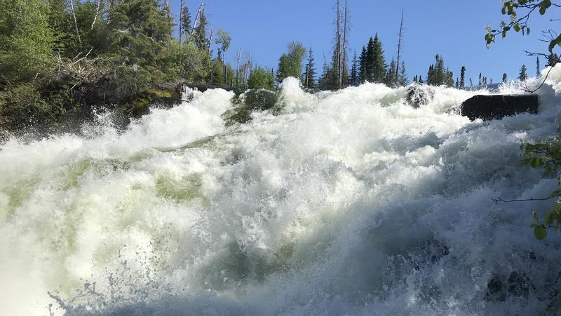
High water levels in northern Sask., SHA advising extreme caution on lakes and rivers

Jul 22, 2020 | 4:44 PM

The Saskatchewan Health Authority (SHA) and the Northern Inter-Tribal Health Authority are advising the public to use extreme caution around lakes and rivers.

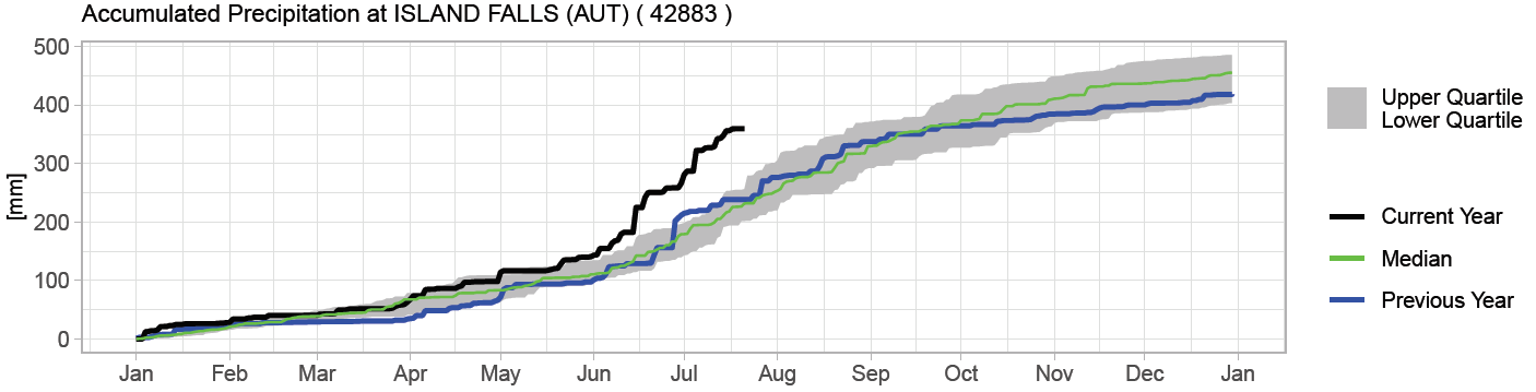
That’s according to a July 22 SHA news release, which notes an abundance of rain this spring has led to high water levels and substantially higher water flows. The SHA recommends the usual precautions for swimmers and boaters such as always wearing a life jacket properly, watching speed on the water, not drinking and boating, not drinking and swimming and not travelling at night.

Extra caution is urged in and near water this year, the release states, and children and non-swimmers should always be closely supervised when around or in water.

“The majority of drowni​​ngs in Saskatchewan occur between May and September,” the release noted. “Although experienced swimmers, boaters and other users of our waterways in the North may understand the need to consistently practice extreme caution, with the flows being higher this year, things can change from calm to dangerous very quickly.”

As the swift currents can cause more erosion of land near the waterways, it is prudent to avoid unstable banks. While in the water, the health authority also cautions about floating debris that will be moving at a fast pace with the potential to cause damage to individuals and vessels.

Extreme precipitation in northern Saskatchewan

The Water Security Agency also provided an update about the rainfall northern Saskatchewan has received, resulting in extremely high cumulative precipitation since April 1 leading to very high flows and lake levels across the Churchill River Basin. In general, cumulative rainfall since that date is near record.

As an example, cumulative annual precipitation data collected at Island Falls is about 130 millimetres higher than the 30-year climate normal. The WSA notes high river and lake levels can be expected for the remainder of summer and, in some cases, such as the mainstem of the Churchill River, into the fall and winter.

Precipitation since January at Island Falls. (Water Security Agency)

The WSA states in most areas flows and water levels are expected to peak, or have peaked slightly lower than previous historical highs. Flows and levels in the Lower Churchill River, including Reindeer River and Churchill River near Sandy Bay, have exceed previous historical highs.

Several areas of low pressure are expected to pass through northern Saskatchewan in the coming days. Light rain is expected through the region today ahead of a stronger system moving in late Thursday. This system is expected to bring general accumulations ranging from five to 10 mm with localized higher amounts due to embedded thunderstorms.

Additional rain is also likely on Friday and through the weekend that could bring general accumulations up to 20 mm or more.

derek.cornet@jpbg.ca

Twitter: @saskjourno

View Comments