The Montreal River flows into Lac La Ronge. The level on the river is the lowest its been in at least 60 years. (Derek Cornet/larongeNOW Staff)
low precipitation

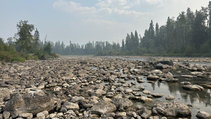
Montreal River at lowest level since 1960s, water level on Lac La Ronge dropping

Jul 24, 2025 | 4:32 PM

The water level on Lac La Ronge has been steadily declining since reaching a peak about one month ago.

That’s according to data from the Water Security Agency (WSA), which shows a peak of 364.23 meters above sea level on June 22. Spokesperson Patrick Boyle said that’s actually pretty close to the normal levels for this time of year; however, the lake will continue to decline due to evaporations from the dry conditions in the area.

“Water levels on Lac La Ronge are primarily driven by rainfall in the spring rather than by snow melt,” a statement from the WSA noted.

“Unfortunately, we have received around 40 per cent of ‘normal’ precipitation across the La Ronge watershed. Without substantial rain, we will see evaporation keep lowering water levels.”

Data from Environment and Climate Change Canada confirms the numbers coming from the WSA. In April, May and June, La Ronge had 58.4 millimeters of precipitation compared to an average of 144.2 mm. There was 49.2 mm of rain in June, 2.6 mm of rain in May and 6.6 mm of rain in April.

The Lac La Ronge Dam, which is located at the northeast section of the lake, is currently open at a minimal flow being released at 15 cubic meters per second.

“The current operational setup has been in place since October 10, 2024,” the WSA statement added.

“This is primarily to provide stable downstream water levels. The WSA Operation and Maintenance group is arranging a trip into the dam in August and plans to make a slight operational adjustment then if needed.”

The low water levels across Northern Saskatchewan are easily visible when observing the Montreal River, which flows between Bigstone Lake and Lac La Ronge. Lac La Ronge Indian Band Elder Tom Roberts, who is in his mid-70s, hasn’t seen it so low since his childhood and never so low for such a long period of time.

“I don’t ever, ever remember it being this low for this long,” he remarked.

“It’s been a long, long time. When you drive up the Montreal River to Bigstone, there are places where you can just about walk across, it is so shallow. It’s still dangerous to be walking on those rocks.”

The low water level is concerning to Roberts. There hasn’t been as much rain as there should be and he explained current conditions are drying out the forest and making it difficult for vegetation to grow.

“This summer, it has been terrible,” Roberts said.

“We have had no rain at all. We had a little bit of rain, if you can call it rain, and the water levels everywhere, even the Churchill River, is still very low.”

derek.cornet@pattisonmedia.com

View Comments